
Our approach
Beyond generic photogrammetry
Our solution automates what generic photogrammetry cannot: component-level quantity take-offs, automated BIM-to-reality discrepancy mapping, and trade-specific progress scoring.

Precision Site Intelligence
Photogrammetry. Reality Capture. Scan to BIM. Transport Canada compliant for Advanced Operations. Serving Ontario and Québec.

Survey-grade capture, Object Recognition, BIM-Ready deliverables. A workflow engineered so drone data becomes decisions you can defend.
RTK/PPK-equipped UAVs and Ground Control Points deliver 2–3 cm absolute accuracy — the threshold at which drone data becomes engineering-defensible.

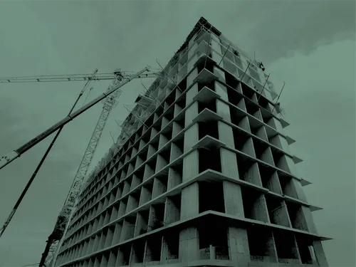
A fine-tuned model trained on Canadian construction environments. Automated component identification (structural steel, studs, plumbing, drywall) and BIM/CAD discrepancy mapping.

GeoTIFF orthomosaics, LAS point clouds, OBJ meshes, and PDF reports. Drop-in compatible with Procore, Autodesk Construction Cloud, and Civil 3D.

Geospatial Data & Reality Capture
Describe your project and our geospatial team will respond within one business day with a tailored acquisition scope.
Labour shortage is compressing schedules. Weekly drone captures replace days of manual surveying — freeing your crews for billable work.
Most rework originates from undetected deviation between as-built and design. Our AI maps BIM/CAD discrepancies within 24–48 hours of flight.
Earthworks and stockpile volumetrics at ±1–2% — defensible in pay applications. Our Transport Canada Advanced Operations certificate authorizes flight over bystanders and controlled airspace.

Weekly or bi-weekly orthomosaics, 3D models, and progress-vs-schedule dashboards. For general contractors who must defend their timeline.
Stockpile, cut/fill, and earthworks volumetrics with LAS point clouds and cross-section reports. For quarries, aggregates, and civil contractors — ±1–2% accuracy, defensible in pay applications.
High-resolution façade, roof, and structural inspection with thermal and RGB deliverables. For owners, developers, and engineers planning refurbishments or due diligence.
Most drone services stop at raw imagery. Munera Geos operates a proprietary model, fine-tuned on thousands of Canadian construction scenes — framed lumber, structural steel, MEP rough-ins, drywall, and concrete pours.
Our approach
Our solution automates what generic photogrammetry cannot: component-level quantity take-offs, automated BIM-to-reality discrepancy mapping, and trade-specific progress scoring.
Knowledge moat
This is our knowledge moat: a system that gets sharper flight after flight and that off-the-shelf solutions cannot replicate.
2026 roadmap
BVLOS operations for linear corridors (pipelines, transmission, highways) and native Procore + Autodesk Construction Cloud integration.
Every format maps to a field use case and a defensible decision.
Geo-referenced site maps and coordination. A single source of truth across Project Owners, GC, Subcontractors and Professionals.
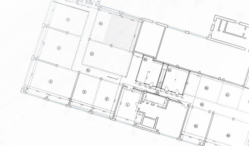
BIM-ready as-builts, clash detection, scan-to-BIM. Survey-grade inputs for design coordination and project handover.
Visualization, client reporting, VDC workflows. Executive-ready communication of site state at every milestone.
Volumetric reports, progress summaries, inspection dossiers. Defensible documentation for pay apps, insurance, and disputes.
Topographic baselines, civil design inputs. Drop-in compatibility with Civil 3D and AutoCAD — no reprocessing.
Based in Montréal. Operating across Ontario and Québec. Compliance, insurance, and precision — verifiable on every flight.
Certified for flights in controlled airspace and over bystanders.
Commercial general liability coverage. Certificates on request.
Every engineering-grade deliverable is validated against Ground Control Points.
Toronto · Ottawa · Mississauga · Montréal · Laval · Québec City · Gatineau.
The answers we give engineering, construction, and procurement teams across Ontario and Québec.
At 2–3 cm absolute accuracy, point clouds reach survey-grade. Teams detect deviation between as-built and design within 24–48 hours of flight, before defects propagate — directly attacking the ~10% of project value typically lost to rework.
Yes. We hold a Transport Canada Advanced Operations certificate, authorizing flights in controlled airspace and near bystanders — the two conditions that cover virtually every urban jobsite across Ontario and Québec.
RTK corrects GPS positions in real time via a base station link. PPK applies the same corrections after landing — more resilient to signal loss. Munera Geos uses both depending on conditions and validates with Ground Control Points.
For volumetric analysis, progress monitoring, and design-stage topographic baselines, yes. For legal cadastral work, no — that requires a licensed land surveyor (AOLS in Ontario, OAGQ in Québec). We frequently collaborate with licensed surveyors to combine legal precision with drone-scale coverage.
GeoTIFF orthomosaics and LAS point clouds are the primary interoperable formats. Native Procore and Autodesk Construction Cloud connectors are on our 2026 roadmap.
BVLOS (Beyond Visual Line of Sight) operations let a single pilot cover multi-kilometre corridors — essential for pipelines, transmission lines, and highways. Munera Geos is preparing BVLOS authorization for 2026 deployment.